Search

The Statistical Innovation and Capacity Building in the Pacific Islands (PACSTAT) project has an overall development objective to improve the quality of welfare data collection and accessibility to comparable welfare data in the Pacific Island Countries (PICs).
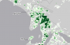
SDD is producing population grids for all Pacific Island Countries and Territories (PICTs) as an alternative to population statistics represented by administrative areas. Population grids represent data using square "cells". SDD is producing them at 100m x 100m (1 hectare).
Through the Australian Centre for International Agricultural Research funded project ‘Agriculture and fisheries for improved nutrition: integrated agri-food systems for the Pacific region’ (FIS-2018-155), commonly referred to as the ‘Food Systems project’, the University of Wollongong, the Pacific Community and the University of Sydney are collaborating on an initiative to establish a regionally harmonised food and beverage trade database.

The Statistics for Development Division conducted a User Focus Survey in 2017. As a result of this survey, and working closely with Statistics New Zealand and a consulting company called Maven in Wellington, we reviewed the SDD, PRISM and other associated websites in order to better meet the needs of users.

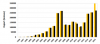
PopGIS2 has been a very popular application for users to access and visualize sub-national datasets through interactive maps and tables. In the last 12 months, PopGIS2 has had 8,000 hits across the 14 sites.
The 13 country sites contain primarily census datasets, though some also include education and poverty indicators, cyclone evacuation centres, school, household and hospital locations and more. There is also a regional site to access NMDI indicators for the Pacific.

SDD’s popular online PopGIS applications now have additional functionality. The thirteen country databases can be accessed from outside PopGIS via a Table Joining Service (TJS). PopGIS allows for TJS services to be consumed as well as served up to be consumed by other applications. A simple QGIS plugin has been developed to allow users to select an indicator which is stored in one of the PopGIS applications and then map the indicator directly within QGIS.


Most National Statistics Offices websites have been using Joomla in the past, and many have expressed their wish to move to WordPress content management system. SDD, who provides support to the majority of NSOs across the Pacific, has addressed this request.
Among other planning, evaluation and indicator frameworks, the Sustainable Development Goals require the production and reporting of statistics that can be disaggregated by various sub-populations, such as sex, age, wealth quintile and disability status. The small size, and geographic spread, of Pacific populations pose significant challenges to achieving disaggregated and statistically significant reporting of progress against development indicators.

The Pacific Data Hub - Microdata Library is a gateway to the Pacific region’s survey, census, and administrative-based microdata and documentation. It is a central repository, online cataloguing and dissemination system of Pacific Island statistical microdata, metadata, reports and documents.