Search
COVID resources can be found below:
Population grids
Population grids have been generated for Pacific Island Countries and Territories to provide population densities for COVID planning purposes. The grids cells are 100m x 100m (1 hectare) and are modelled using most recent census data projected where possible to 2020.
Full datasets are accessible from the Population Grids page in the innovation section.
Civil Registration and Vital Statistics (CRVS) material
Download the Impact of the COVID-19 pandemic on operations of national civil registration and vital statistics (CRVS) systems 2020 report.
Economic and Social Vulnerability to COVID
Download a collection of economic and social vulnerability indicators below including real GDP, remittances and tourism earnings, trade and production, domestic demand, employment, government fiscal and debt positions, poverty and health.
Read about Impact of COVID-19 on International Merchandise Trade (IMTS) in the Pacific.
Here is a recommended list of administrative data to be used as leading indicators of macroeconomic impacts.
Visitor arrival numbers slump in the Pacific Island Countries and Territories.
COVID-19 Pandemic, Geospatial Information and Community Resilience: Global Applications and Lesson book.
Economic Brief
Presentation Documents and Links Data Tables Highlighting Key Areas of Economic & Social Vulnerability in PICTs xlsx Covid economic lead indicators xlsx Economic Indicators 1Q2020 Summary Analysis link Economic Indicators 2Q2020 Summary Analysis link Economic Indicators 3Q2020 Summary Analysis link Economic impacts in the Pacific Half yearly (Dec 2020) link Economic Indicators 4Q2020 Summary Analysis link Economic Indicators 1Q2021 Summary Analysis link Economic Indicators 2Q2021 Summary Analysis link Economic impacts in the Pacific Half yearly (July 2021) link Economic Indicators 3Q2021 Summary Analysis link Economic Indicators 4Q2021 Summary Analysis link Economic Indicators 2021 Annual Summary Analysis link Pre-COVID-19 baseline indicators for PICTs
As the world is facing an unprecedented crisis with the Coronavirus (COVID-19), the Pacific region has not been as affected as the rest of the world when it comes to infection rates, but the economic implication of the pandemic has been catastrophic across many of the 22 Pacific Island Countries and Territories (PICTs).
During the pandemic, many data are being collected to assess the socioeconomic impacts of COVID-19 on the Pacific populations. For example, the World Bank is currently implementing High Frequency Surveys on COVID-19 in Papua New Guinea and the Solomon Islands while other organisations, such as ILO, UN Women and UNICEF, are conducting similar Socioeconomic Impact Assessments. In addition to specific surveys to evaluate the impact of COVID-19 on the economy and labour market, regularly implemented nationally representative surveys, such as Household Income and Expenditure Surveys (HIES) or Labour Force Surveys (LFS), continue to be implemented. Together, the COVID-specific surveys and ongoing conduct of regular surveys will help policy makers and planners to evaluate the impact of COVID-19.
It is, however, important for comparability purposes to have access to pre-COVID-19 baseline information, which will serve as a benchmark to evaluate the impact that the global pandemic has had on Pacific economies and households, and to identify populations that are most vulnerable to the health and economic fallout.
School Locations
Schools in all Pacific Island Countries and Territories have been included in their respective Education Management Information Systems in 2015 by the Statistics for Development Division of SPC. This data can be used for applications such as disaster mitigation and optimise emergency response and service delivery.
Recent Updates
Pre-COVID-19 baseline indicators for PICTs
Read our Pre-COVID-19 country Baseline metrics.COVID-19 Impacts on Visitors arrival and on Economy in the Pacific
New publications on the impact of the COVID-19 on Visitor arrival and on the Economy in the region have been released.Impact of COVID-19 on International Merchandise Trade (IMTS)
A blog has just been released in regards of the Impact of COVID-19 on International Merchandise Trade (IMTS) in the Pacific.Pacific Statistical / Economic Briefing of COVID-19 Economic Impacts
A Pacific Statistical / Economic Briefing of COVID-19 Economic Impacts has just been uploaded along with associated data.Measuring and monitoring the socio-economic impacts of the COVID-19 pandemic on the economies of the region
See here a recommended list of administrative data to be used as leading indicators of macroeconomic impactsHigh-frequency Phone Surveys (HFPM) of Households to Monitor the Impact of COVID-19
Read about High-frequency Phone Monitoring Surveys (HFPM) of Households to Monitor the Impact of the COVID-19 Pandemic on the Socioeconomic Situation, Coping Strategies and the Effectiveness of Response Measures in Pacific Island Countries and Territories.
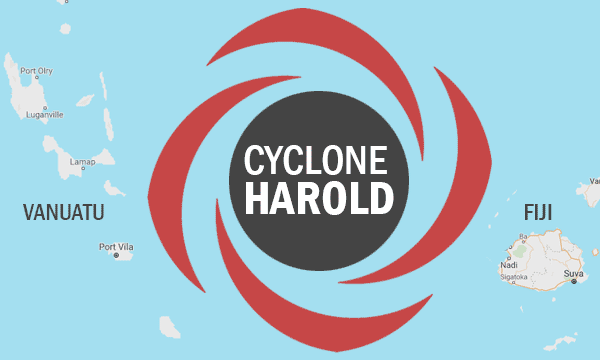
Below are a list of resources which could be useful for Cyclone Harold disaster relief.
- Vanuatu
-
- Household by main toilet type - 2016 Mini Census (hh)
- Household by main material used for walls - Pie Chart - 2016 Mini Census (hh)
- Household by main material used for roofs - Pie Chart - 2016 Mini Census (hh)
- Population by functional age groups and sex - total population 0 - 14 years old - 2016 Mini Census (pers)
- Population by functional age groups and sex - total population 60 years old or more - 2016 Mini Census (pers)
- Proportion of people who report some disability - (6+) - 2010 Vanuatu Hardship and Poverty Report (%)
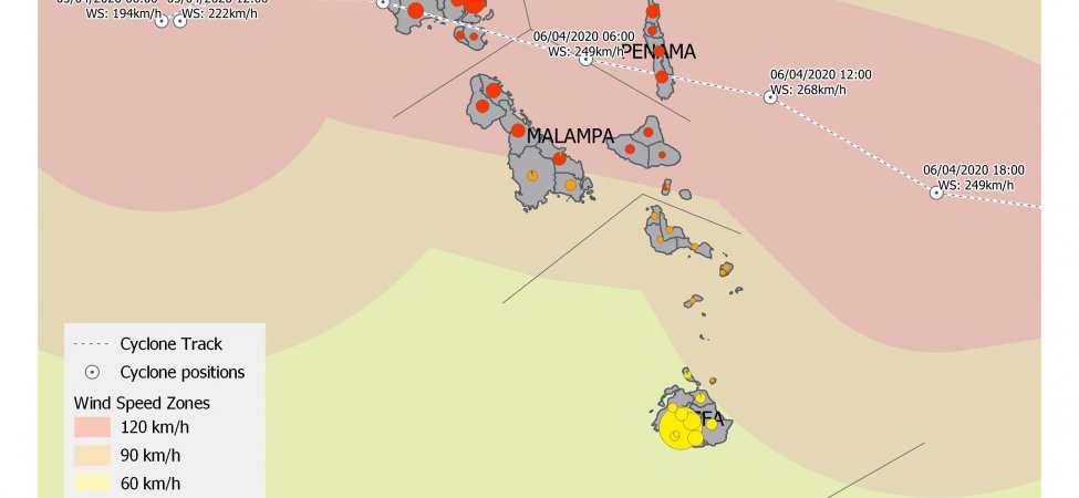
Click to enlarge map 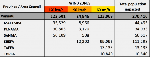
Click to download full data (excel) All material relating to the Vanuatu impact map can be downloaded from the Pacific Data Hub here.
- Fiji
-

Click to enlarge map 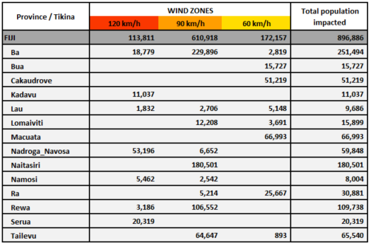
Click to download full data (excel) All material relating to the Fiji impact map can be downloaded from the Pacific Data Hub here.
- Tonga
-
- Household by toilet facility - 2016 Census
- Household by main material of walls - 2016 Census
- Household by main material of roofs - 2016 Census
- Population by functional age groups - Total 0 to 14 years - 2016 Census
- Population by functional Age Groups - Total 60 years or more - 2016 Census
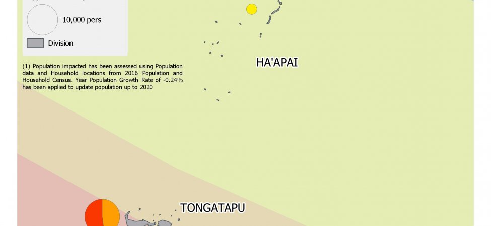
Click to enlarge map 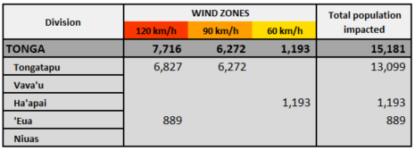
Click to download data (Excel) All material relating to the Tonga impact map can be downloaded from the Pacific Data Hub here.
School Locations
Download school locations here.
Recent Updates
Pre-COVID-19 baseline indicators for PICTs
Read our Pre-COVID-19 country Baseline metrics.COVID-19 Impacts on Visitors arrival and on Economy in the Pacific
New publications on the impact of the COVID-19 on Visitor arrival and on the Economy in the region have been released.Impact of COVID-19 on International Merchandise Trade (IMTS)
A blog has just been released in regards of the Impact of COVID-19 on International Merchandise Trade (IMTS) in the Pacific.Pacific Statistical / Economic Briefing of COVID-19 Economic Impacts
A Pacific Statistical / Economic Briefing of COVID-19 Economic Impacts has just been uploaded along with associated data.Measuring and monitoring the socio-economic impacts of the COVID-19 pandemic on the economies of the region
See here a recommended list of administrative data to be used as leading indicators of macroeconomic impactsHigh-frequency Phone Surveys (HFPM) of Households to Monitor the Impact of COVID-19
Read about High-frequency Phone Monitoring Surveys (HFPM) of Households to Monitor the Impact of the COVID-19 Pandemic on the Socioeconomic Situation, Coping Strategies and the Effectiveness of Response Measures in Pacific Island Countries and Territories.